And so it came to pass that my next leg of the Cape Wrath Trail had arrived. The end was in sight, but this next section was proving to be a quandary to plan. Having finished at Inchnadamph after an enjoyable three days in April 2014, I wanted to reach Rhiconich with this next section. That would leave me within striking distance of the Cape to be finished in 2016 perhaps.
As with all of my previous legs, I wanted to include some Corbetts on the way, and this section offered four potential summits. Glas Bheinn near Inchnadamph was a given; the primary CW route passed only a kilometre or so from the cairn. Beinn Leoid was a tougher prospect with no obvious route to its summit from the south. I had consulted the excellent Geograph website for this area, and after making contact with a busy contributor, Gordon Brown, I discovered an excellent track leading north across the moors to the road which might offer sanctuary. After Achfary, Meall Horn appeared to be a straightforward summit en route to Foinaven. But that assumed I would be going over Foinaven. If included, it would mean a long day above 500m. There were also the bothies and lochs of Loch Coul and Dubh to consider. Long stared at on maps, could I afford to bypass these? And finally, there was transport back to the start to think about.
As far as I could determine, the only paid option was the D&E operated Durness Bike Bus that shuttled between Inverness and the north once a day. Unfortunately, the season for this bus only began late in May. This of course determined my departure date; I chose the late May bank holiday. Of course, as with most of the weather since the April 2015 Easter weekend, westerly or nor'westerly air had been pummelling Scotland. This was not to change for the May Bank Holiday. Therefore I knew I'd be using my waterproofs at some stage on the trip. I had hoped to use my new Salomon Fellraiser shoes, aswell as the new, very lightweight Mountain Equipment sleeping bag recently purchased in Braemar. However, I chickened out of the Fellraisers and retained my more traditional boots. The sleeping bag was a trickier decision. It had a so-called 'Comfort Rating' of three degrees of temperature with an Extreme minimum of -2C and a minimum Comfort of 6C. Snow was forecast for the highest peaks on the Sunday so it wasn't going to be a warm weekend. I felt that with two silk-liners plus my down gilet, I might be able to retain some warmth in the lightweight bag.
Saturday 23rd May - Inchnadamph to Glendhu
29km
1430m
8hours

A high pressure system was moving eastwards over the British Isles so that the day dawned bright, calm and dry. I left Edinburgh at 06:07 and rolled into the car park at Inchnadamph at 10:01. The car park was busy, with a couple of other cars emitting occupants ready for a day on the hill. Within a kilometre, I had reached my connection with last year's walk.
 |
| I rejoin the route north at my 2014 departure point. |
A quick photo, and I stepped onto the excellent hill path to the north. It was a classically engineered stalker's path which was well drained and followed the driest ground. I was able to make fast progress and soon enough was closing on a trio of other walkers in the distance. I noticed one of them carrying a fishing rod. Ahead on the skyline was the bealach below Glas Bheinn. Short of Loch Fleodach Coire, the trio left the path and headed to the shore of the loch. I crossed the stepping stones from the loch outflow; not what I had expected and I could see that in wet weather I might have struggled with that crossing!
On the shattered rocky quartzite bealach, the wind blew strongly from the south west. A change was on the way. After dumping my pack, I trotted up onto the narrow eastern ridge of Glas Bheinn which provided some pleasant views. I realised the Loch of the Green Corrie was in view. On the summit plateau, I jogged across the bouncy moss to the cairn and took some panoramas. The Assynt hills to the south and west were prominent but darkening skies over the Atlantic and swirling cloudscapes suggested it wouldn't be long.
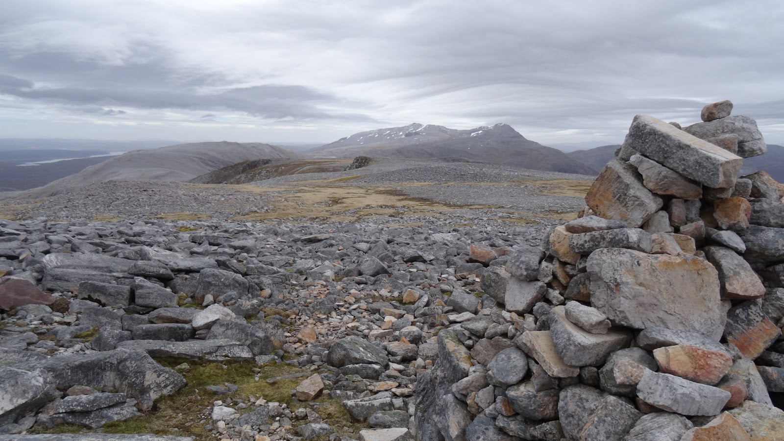 |
| The summit of Glas Bheinn looking towards Ben More Assynt |
 |
| Looking north towards Beinn Leoid and day ahead |
Back at the pack, I refuelled with a bit of sarnie and studied the map. There was a decision to be made whether I headed to the low ground and followed the coast round Lochs Coul and Dubh or whether I stuck to my original plan of forging a pathless route to Beinn Leoid. I made some estimates on timings and decided I didn't want to be arriving in a bothy at 3pm. It was also still dry. Perhaps I was suffering from the attitude of "I've travelled all this way, I can still bag it". Greed and recklessness.
From Bealach na h-Uidhe, the stalkers path zig-zagged off the steeper northern slopes below Beinn Uidhe, but I was still dry-shod. I reached the tri-fork of paths at 280271 soon enough. It was a curious spot, perched between two small lochans with a cairn as a signpost of the path division. I was still not certain of the best choice and spent some more time looking at the map and the sky. Eventually I bit-the-bullet and decided on Beinn Leoid. I turned right (SE) and followed the path gradually downhill towards a small loch a couple of kilometres away beyond a rocky gorge. I lost the path of course, which disappeared in peat/rocks/numerous streams so that when I reached the loch shore, my feet were wet. Crossing the in-flow of the loch at 301256 felt wild and I knew I was really remote. No mobile reception here, be careful not to trip or fall. What did I do next? I slipped on a rocky outcrop and fell onto my side and slid off a a wee crag to land in a muddy squelch below. Bah! Time to turn left and head back NW.
 |
| At the watershed, no mobile reception, the middle of nowhere. |
 |
| On the side of Beinn Leoid |
 |
| From the Beinn Leoid triangulation point - the weather starting to close in. |
 |
| Looking down the norther ridge of Beinn Leoid - to shelter perhaps? |
The good track mentioned by Gordon Brown was visible, but I knew it was long and stayed high and I didn't have a set place to camp. Alternatively, there was the bothy of Glendhu on the shore of Loch Gleann Dubh which was on the main CW route. I estimated the bothy to be 5-6kms away. With the weather deteriorating, and my feet already wet, I opted for the bothy and set off down the NNW ridge of Beinn Leoid towards the path marked on the map emanating from Gleann Dubh. It was on the descent as my mind wandered I suddenly realised I had forgotten to pack one of the most important items of a wild-camper's kit - a spoon!! It may not sound bad, but have a think about that. What was I going to eat porridge with? What was I going to eat rehydrated bolognese with? I cursed myself as I sploshed across the moor, disturbing a couple of deer on the way.
Eventually I found the end of the path, which was actually a two-wheeled vehicle track that wound an efficient gradient into the glen and a new wooden bridge at 309329 where the track joined a more established route of gravel. For the next 2km, I entered a land that time forgot. This glen is one of the most spectacular I have had the pleasure to walk through with steep sides of rock and white waterfalls crashing down. The track wound its way around steep shoulders and abutments above the gorge below. I was stunned at the beauty of the place, and so surprised to have never heard of it. Perhaps my demeanour and the inclement weather had something to do with it but I will have the memory of Gleann Dubh for a long time.
 |
| In Gleann Dubh - dark and foreboding, prehistoric. |
 |
| At last, salvation and shelter at Glendhu bothy. |
Soon enough the track had reached sea-level and I could smell the salty air. Thoughts of my missing spoon returned and I pocketed up a mussel shell from the ground in the hope I could fashion it into a tool. The track wound round the shore of the loch and I arrived at the wonderful bothy of Glendhu. Another empty one. A two-up two-down building, I chose the left-hand upper room as my bedroom and dumped my gear before spending the next while in the main room downstairs to read the bothy book and enjoy the view outside. To my good fortune, some kind bothier had left some plastic cutlery behind - it was mine now!! The rain had abated by this time, and the wind had dropped - the white caps on the loch had died. In the shallows the loch-head was a fisherman's buoy marking a creel no doubt. A seal made ripples as it played with the rope on the buoy. I cooked my dinner and retired to bed.
 |
| My accommodation for the night in Glendhu bothy. |

Sunday 24th May - Glendhu to Lone
17km
540m
4.5hours

My plan today was to reach Lone or the shoulders of Foinaven so not a long distance. Therefore I wasn't up at the crack of dawn. After breakfast as I rolled my thermarest, I heard the latch of the door go downstairs and a voice greeting "Hello!". I shouted back my greeting and went down to see who it was. A fellow CW trailer who had spent the night at the bothy of Glen Coul. He was a bit driven, but pleasant enough. He seemed to be following a guidebook route without any deviation or uncertainty. He told me he was hoping to walk the whole way in 10days which was an impressive pace, but when he revealed he had hitched a lift from Oykel Bridge to Inchnadamph the day berfore, he dropped in my estimations. That is not the CW trail. Anyway, he left after his break and I carried on packing up before saying my farewells to this great bothy.
 |
| Leaving Glendhu bothy |
The route for the day would be fairly low-level (compared to the day previous), only reaching 400m, but the wind was still gusting up the loch and as I passed the red cliffs of Creag Ruadh, I could see the waterfalls blowing upwards. At Maldie after 3km, I had caught up the fellow CW trailer; he was walking slowly (not someone who'd I expect to be completing in 10days!!), and I passed him as the path diverted around some new hydro works descending from the Maldie Burn.
 |
| Maldie Burn hydro works |
I followed the good track up the west of the river, peering at the muddy scars on the east from the hydro works. After a break for food, I continued on the track which began an ascent northwards to join the more major path crossing from Kylesku. Beside the track every fifty metries or so were posts marking a buried electric cable. They did spoil the prospect a little. At the lonely shieling on Bealach nam Fiann I sheltered behind a wall from the keen wind to eat some chocolate. Continuing briefly north, the track then began a steep descent to the NE below the cliffs of Meall Diamhain. It was a well maintained vehicle track and progress was fast. The views ahead included the iconic cone of Ben Stack and the remarkable cliffs of Arkle. True to the forecast, Foinaven and Meall Horn were obscured by grey clag.
 |
| On the summit of the pass between Loch Dubh and Achfary. The other CW trailer on the horizon. |
 |
| Looking north towards Meall Horn and Arkle (left) |
I reached the road SE of Achfary and plodded through the wee hamlet just as the heavens broke. Near the school, I took the opportunity to dump some rubbish in the bins by the road before heading to the path at An Earachd. I was last here in early 2012 when I had climbed Ben Stack before following the same track towards Lone and Arkle. Although slightly warmer today than 3years earlier, it was more wet and windy and I walked with a sense of foreboding about the next few hours. Soon enough I had passed the locked bothy at the aptly named Lone and was in the wee forest at the foot of Arkle. The trees dripped.
 |
| The split rock marking the gateway to wilder lands. I camped in the trees behind. |
It was only two-thirty but ahead was a long stretch of high ground and with the current weather and forecast, I didn't fancy an exposed hillside for camping out on. After some scratching about, I found a dryish flat area of ground near the path in the trees and pitched the tent. What followed was the worst night's camping I've had for a long while. My pathetic 'lightweight' sleeping bag offered little warmth in the freezing temperatures so when 6am arrived, I was glad the night was over.
Monday 25th May - Lone to Kinlochbervie
24km
1450m
8hours

Sticking my head out of the tent, I couldn't see the mountains due to low cloud and rain blowing down the glen. Rain dripped from the trees. Dismayed, I laid out the map on the tent floor and looked at the options. I was due in Rhiconich at 4.00pm to catch the Durness Bike Bus on its return to Inverness, the original plan had been to traverse the ridge of Foinaven and down the A838, but in this weather, I'd be better starting low and crossing the moor directly to Rhiconich. Making my choice, I zipped up, and dropped the tent. In the 15minutes it took me to pack up, the mountains suddenly appeared, and the rain took a rest. Aha! The fickle mind switched back to Plan A. Back to the hills!
The track was streaming, but I made good progress up towards the Bealach Horn between the Corbetts of Meall Horn and Foinaven. Sadly, the weather closed in again, and at 400m, I was in the cloud. Bizarrely, at the same moment, a mountain-biker came trundling out of the mist, with a fully equipped bike. I waved to him and he waved back. A few hundred metres later came another bike, this time the rider stopped and asked how many others I'd seen. They seemed to be on some sort of organised event/race. I reached the summit of the bealach at 510m. Visibility was down to 30m, the wind was driving rain from the west. After a quick map check, I greedily decided to head south-east towards Meall Horn - only 250m higher, 1.5km away. But very quickly I realised this was an error of judgement. The ground was steep, and my hands were freezing in the wet wind. I couldn't see anything - it was only going to get worse the higher I went. Heading this direction wasn't getting nearer to that bus. So I returned to the bealach.
I ate some chocolate and got the phone out to text home. Things were pretty dire. If I returned down the hill to restart Plan B across the moors, I would waste valuable time and possibly miss the bus. Alternatively, for a new Plan C, I could perhaps head north into Strath Dionard and catch the bus on the road near Gualin House. But I had no idea about the route round Loch Dionard or how long it would take. Back to Plan A and over Foinaven. Zips up, gloves on, straps tightened, Radio 2 in the ears, I set off up into the storm. It was 9am.
 |
| My views on Foinaven were non-existent - such a shame! |
Once onto the main ridge of Foinaven, it was obviously easy to follow, but I cursed the weather. I saw absolutely nothing of the mountain. By the time Jeremy Vine was about to start ranting, I was dropping out of the cloud off Ceann Garbh.
 |
| Looking towards Kinlochbervie and Loch Inchard from the shoulder of Ceann Garbh |
The next 3 or so kilometres crossed some wild country of pathless bogs and heather, interspersed with deep stream channels and studded with lochans. Of course, I lost any FM reception, so resorted to Stevenson's "The Invisible Man" audio book. With great relief, I reached the salvation of the tarmac at 278544. It was only 2pm, and I realised I still had some time until the bus arrived so decided to extend the day towards Kinlochbervie. The weather had improved enough to pack the waterproofs, and I strode past the General's Loch on a sheep track with a new lease of life.
 |
| London Stores at Badcall. Foinaven still under a blanket of cloud. |
Back to the tarmac of the B801 at Achriesgill, I plodded on towards Inshegra and eventually the esoteric 'London Stores' at Badcall. Things were good; the sun was almost making an appearance and I bought some rewards of Doritos & Irn Bru to eat on the bench outside. After another couple of kilometres, I reached a suitable spot to wait for the bus at the back of the harbour in Kinlochbervie with thirty minutes to spare. I phoned D&E coaches in Inverness to make sure the bus was on its way, hung my wet gear on a fence to dry in the breeze and waited.
Eventually, after a roundabout trip via Lochinver, I was dropped at Inchnadamph at 6pm and drove home satisfied with another wild weekend.

No comments:
Post a Comment